


Lozère j 2

rigol05
User
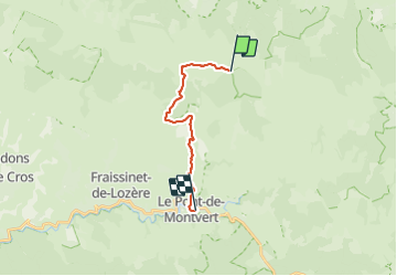

Length
13.8 km

Max alt
1699 m

Uphill gradient
193 m
Km-Effort
18.6 km

Min alt
873 m

Downhill gradient
845 m
Boucle
No
Creation date :
2015-07-05 00:00:00.0
Updated on :
2015-07-05 00:00:00.0
3h34
Difficulty : Medium

FREE GPS app for hiking
 SityTrail
IGN / Geographical institutes
SityTrail Plus
The world is yours!
About
Trail Walking of 13.8 km to be discovered at Occitania, Lozère, Mont Lozère et Goulet. This trail is proposed by rigol05.
Description
Etape du Col des Finiels au Pont de Montvert Itinéraire très beau sur un parcours varié.
Positioning
Country:
France
Region :
Occitania
Department/Province :
Lozère
Municipality :
Mont Lozère et Goulet
Location:
Mas-d'Orcières
Start:(Dec)
Start:(UTM)
561201 ; 4919267 (31T) N.
Comments